MA- Cape Cod
Human Forecasts
> Daily Briefing
> Forecast Blog
Real-Time Data
> Dynamic Map
> Radar Map
> Wind Obs Summary
Computer Forecasts
> Model Tables
> Wind Forecast Map
> Radar Map
> Tidal Currents Map
More Maps 
Other Resources
Watches/Warnings
>None Active
|

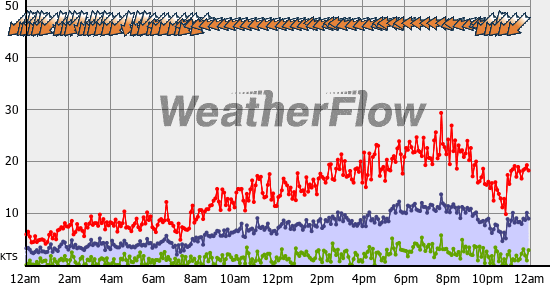
Thursday, Oct 30, 2025
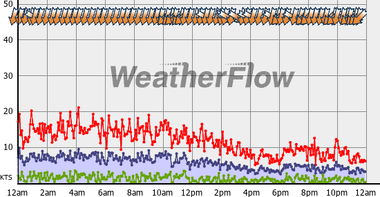
Wednesday, Oct 29, 2025
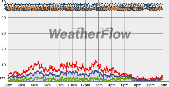
Tuesday, Oct 28, 2025

Monday, Oct 27, 2025

Sunday, Oct 26, 2025

Saturday, Oct 25, 2025
Friday, Oct 24, 2025
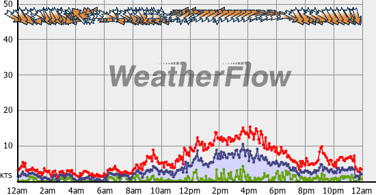
Time displayed is based on Waquoit Bay, MA local time. The wind graph displays observations as reported in miles per hour. The blue line and shaded area represents the average wind speed, the red represents gust value, and the green represents lull. Dots along the lines indicate time of data reported. The yellow arrows represent observed wind direction. An arrow pointing down indicates wind blowing from north to south, and is commonly referred as a "north wind". Note: frequency (and latency) of data is a function of the individual reporting station. Many non-WeatherFlow stations report data only once per hour. Check sensor notes for information on data source. Please read and understand disclaimer before using this information. |
